Carbon Market Network


A forest carbon credit is only as good as the data behind it.
If the numbers are wrong, the credit is wrong. Buyers overpay, developers lose trust, and the climate gets nothing in return.
That is why forest carbon MRV companies matter so much. They measure how much carbon a forest really holds, how that changes over time, and whether the change is real.
This guide covers the top 7 forest carbon MRV companies and forestry carbon monitoring technology providers. You will see what each one does, where it fits best, and how to pick the right partner for your project.
What Are Forest Carbon MRV Companies?
Forest carbon MRV companies are firms that help measure, report and verify the carbon stored in forests. Most of them use satellites, LiDAR, drones, field data and machine learning.
Some sell raw data. Others sell ratings, software or full project support.
MRV in Plain Words
MRV stands for Monitoring, Reporting and Verification.
- Monitoring means measuring forest carbon stocks and changes over time.
- Reporting means documenting those results in a standard format.
- Verification means an independent party checks the results.
Every credible forest carbon project needs all three.
Why Forests Need Digital MRV
Forests are huge, remote and constantly changing. A team on foot cannot walk every hectare every year.
Traditional field surveys also take months and cost a lot. They give you a snapshot, not a movie.
Digital MRV fixes this. Satellites and AI can scan whole landscapes quickly and repeat the scan often. Field data still matters, but it now trains and checks the models instead of doing all the work.
You will also see the terms dMRV, digital MRV and remote sensing for forest carbon. They all point to the same idea.
Carbon Market Insider Newsletter
Weekly insights on carbon markets, climate policy, carbon credits, and sustainability.
How Forestry Carbon Monitoring Technology Works
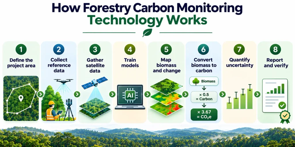
Most forest carbon MRV companies follow a similar workflow. Here is the simple version.
- Define the project area. The company draws the exact boundary of the forest or planting site.
- Collect reference data. Field plots, airborne LiDAR and ground scans give trusted measurements of tree size and biomass.
- Gather satellite data. Optical, radar and spaceborne LiDAR data cover the area at regular intervals.
- Train models. Machine learning links satellite signals to the reference measurements.
- Map biomass and change. The model estimates canopy height, canopy cover and aboveground biomass for every pixel.
- Convert biomass to carbon. Roughly half of dry biomass is carbon. Carbon is then converted to carbon dioxide equivalent by multiplying by 3.67.
- Quantify uncertainty. Good providers show how confident they are in each number.
- Report and verify. Results go into project documents that auditors and registries can review.
The Main Technologies Behind the Maps
| Technology | What it measures | Strength | Limitation |
|---|---|---|---|
| Optical satellites | Tree cover, greenness, land cover change | Frequent, affordable, high detail | Clouds block the view |
| Radar (SAR) | Forest structure, even through clouds | Works day and night, all weather | Harder to interpret alone |
| Spaceborne LiDAR | Canopy height and structure in sample footprints | Direct height data from orbit | Does not cover every pixel |
| Airborne LiDAR | Detailed 3D forest structure | Very accurate | Expensive, covers limited areas |
| Drones | Tree counts, young plantation growth | Ultra-high detail | Small area per flight |
| Field plots | Tree diameter, height, species | The ground truth | Slow and costly |
| Machine learning | Links all of the above into maps | Scales across landscapes | Needs good training data |
The best providers combine several of these. No single sensor does everything well.
New sensors keep arriving too. The European Space Agency’s Biomass satellite, for example, carries a radar built to measure forest biomass from orbit.
Top 7 Forest Carbon MRV Companies at a Glance
| Company | Based in | Core strength | Best for |
|---|---|---|---|
| Sylvera | London, New York, São Paulo | Biomass data plus independent carbon ratings | Buyers, developers, registries |
| Planet Labs | San Francisco | Global forest carbon datasets at 30 m and 3 m | Analysts, platforms, supply chain teams |
| Chloris Geospatial | Boston | Direct biomass change estimates | Registries, raters, project monitoring |
| Kanop | Paris | AI and satellite MRV for nature-based projects | Developers and investors |
| Space Intelligence | Edinburgh | Audit-grade forest and habitat mapping | Developers, corporates, deforestation compliance |
| Treeconomy | United Kingdom | Satellite plus drone monitoring | Reforestation projects |
| Earthshot Labs | United States | Open-source verification tools and field app | Restoration and agroforestry projects |
1. Sylvera
Sylvera is best known for independent carbon credit ratings. It also sells forest biomass data that anyone can use, with or without a rating.
What Sylvera Does
Its Biomass Atlas product delivers aboveground biomass and canopy height data at 10 to 30 meter resolution. It offers a long historical record and quarterly monitoring, and it is available through an API.
The company says the product is calibrated against more than ten million dollars of LiDAR field research across more than 250,000 hectares. It also says its multi-scale LiDAR approach keeps errors below 9 percent at project scale. Treat those as company claims and ask for the validation reports.
Why It Stands Out
Sylvera collects its own ground truth. It scans forests in places like Belize, Gabon and Mozambique, then uses that data to calibrate satellite models.
It also launched the Open Carbon Data Project in the Brazilian Atlantic Forest. The project is backed by The Rockefeller Foundation and Meta, with a combined 900,000 dollars in funding. Partners include the State University of Santa Cruz, World Resources Institute and Symbiosis Coalition.
The plan is to publish an open, benchmark-grade forest carbon dataset under a free license. That helps the whole market test and improve its models.
Best For
- Buyers who want independent proof before purchasing credits
- Developers who need a neutral biomass benchmark
- Registries and governments that need wall-to-wall coverage, including jurisdictional programs
Things to Know
Sylvera works as a data and ratings company. It does not run your project’s day-to-day field operations.
2. Planet Labs
Planet operates one of the largest satellite fleets in the world. It turns that imagery into ready-to-use forest carbon datasets.
What Planet Does
Planet offers two forest carbon products.
- Forest Carbon Diligence gives annual global maps at roughly 30 meters. It covers canopy cover, canopy height and aboveground carbon density, with uncertainty layers and a long archive.
- Forest Carbon Monitoring gives quarterly maps at roughly 3 meters, built on PlanetScope imagery. This level of detail can spot small disturbances such as selective logging.
Planet trained these models on a large library of airborne LiDAR and millions of spaceborne LiDAR samples from NASA’s GEDI mission. A peer-reviewed paper in Forest Ecology and Management describes the Diligence system as a digital MRV tool. The company’s own validation report compares it against GEDI, ESA CCI Biomass and national statistics.
Why It Stands Out
Coverage and consistency. You can look at any forest on Earth, within the product’s latitude range, using the same method.
That matters for supply chain monitoring and for checking projects in many countries at once. Carbon rating firm BeZero Carbon was an early partner on both products.
Best For
- Carbon platforms and rating firms that need global data
- Teams with GIS or data science skills
- Companies tracking deforestation risk across sourcing regions
Things to Know
Planet mainly sells data. You still need analysts, or a partner, to turn the maps into audit-ready project reports.
3. Chloris Geospatial
Chloris Geospatial focuses on one big question. How much biomass is in the forest, and how is it changing?
What Chloris Does
The company estimates aboveground biomass directly from satellite data using sensor fusion and machine learning. It produces annual estimates and tracks deforestation, degradation and regrowth, with a record going back about 25 years.
Direct biomass tracking matters because many older methods look only at forest area. A forest can lose carbon through degradation without losing its tree cover. Biomass data catches that.
Why It Stands Out
Chloris has built a strong partner network.
- BeZero Carbon uses its biomass data in carbon ratings, and Chloris receives ground-truth plots in return for model validation.
- Trove Research uses its data to assess integrity across hundreds of forest projects.
- The Equitable Earth Coalition named it the exclusive provider of digital MRV for its forest carbon standard.
- Its data is available inside platforms such as Earth Blox and Upstream Tech’s Lens.
The company raised 8.5 million dollars in a Series A round to scale its work.
Best For
- Registries and standard setters
- Rating firms and due diligence teams
- Developers who want an independent biomass check on REDD+ and improved forest management projects
Things to Know
Chloris is a specialist data provider. Pair it with field teams and a verification body for a complete MRV system.
4. Kanop
Kanop is a Paris-based company that builds an AI and satellite platform for forest carbon MRV and nature-based project due diligence.
What Kanop Does
Kanop uses optical, radar and LiDAR data from agencies such as NASA, ESA and JAXA. It builds digital twins of forests to estimate canopy height, biomass and carbon stock.
Its platform supports the full project cycle.
- Project screening and due diligence
- Dynamic baseline generation
- Biomass and carbon stock tracking over time
- Land use change and deforestation monitoring
- Biodiversity and flora monitoring
It covers REDD+, afforestation and reforestation, improved forest management and blue carbon projects.
Why It Stands Out
Kanop talks openly about alignment with the newest rules. When ACR formalized a framework letting satellite-derived models act as the primary method for estimating forest carbon stocks, Kanop said its biomass products already fit the requirement. It also says it spent more than two years calibrating its system with clients to meet the statistical thresholds.
It integrates with the CEEZER carbon portfolio platform, so buyers can see MRV data next to the credits they hold. It also supports supply chain work tied to the EU Deforestation Regulation.
Best For
- Developers preparing projects for new remote-sensing-based methodologies
- Investors who need project screening and ongoing monitoring
- Teams that want one platform for carbon and nature data
Things to Know
Kanop is a younger company, so ask for case studies that match your forest type and region.
5. Space Intelligence
Space Intelligence is an Edinburgh company that makes high-accuracy maps of forests, habitats and carbon stocks.
What Space Intelligence Does
The team was founded by Dr. Murray Collins and Professor Ed Mitchard, who began their careers measuring biomass in African forests. Today the company combines multiple satellite sources, field plot data and machine learning to map forest cover, deforestation, degradation and carbon.
It also built GOOD-COP, an interactive map of forest carbon projects. It covers projects certified under Verra’s Verified Carbon Standard, Plan Vivo and the Woodland Carbon Code.
Why It Stands Out
Space Intelligence describes its data as audit-grade, with a strong science background. It raised Series A funding led by AzurX Space Ventures with participation from Intercontinental Exchange.
Regulation now drives much of its work. Professor Mitchard has said the EU Deforestation Regulation became about half of the business. That gives the company deep experience in the type of evidence regulators and auditors ask for.
Best For
- Project developers who need baseline and monitoring maps
- Corporates that must prove their supply chains are deforestation-free
- Investors who want independent forest data
Things to Know
Strong mapping does not replace field validation. Plan for both.
6. Treeconomy
Treeconomy is a UK company that measures and monitors forest carbon with remote sensing, drones and machine learning.
What Treeconomy Does
The company pairs satellite imagery with detailed drone surveys. It detects tree crowns, counts trees and estimates carbon growth in young planting projects.
Treeconomy built its approach with help from ESA BIC UK. The Satellite Applications Catapult reviewed its imagery analysis methods, and forest monitoring experts at the University of Leicester helped develop its detection models.
Why It Stands Out
Drones give much finer detail than satellites in young plantations. Small trees are hard to see from orbit. Combining both levels of detail can raise confidence in early-stage reforestation numbers.
Treeconomy is also one of the eight nature-based providers Isometric partnered with to support projects under its Biosphere protocols.
Best For
- Reforestation and tree planting projects
- Landowners who need proof of growth
- Buyers who want traceable, well-monitored removals
Things to Know
Drone surveys cover limited areas. The approach fits projects of a manageable size better than national programs.
7. Earthshot Labs
Earthshot Labs is an open-source community and technology company working on forest carbon, soil carbon and water restoration.
What Earthshot Labs Does
It offers two main tools.
- LandOS is a platform for carbon credit verification. It produces multi-layered maps that show what drives change in a project area.
- Biome is an AI-powered field app for forest inventory. Earthshot says it delivers audit-ready field data five to ten times faster than traditional methods.
The science team also uses ecosystem models such as CLM-FATES alongside its database of restoration outcomes to predict carbon and vegetation dynamics.
Why It Stands Out
Earthshot connects field data and satellite data in one workflow. It also works on the ground, supporting forest protection, tropical and temperate restoration, and multistrata agroforestry.
Like Treeconomy, it is an approved Isometric partner for nature-based projects.
Best For
- Restoration and agroforestry developers
- Teams that want faster, structured field inventories
- Projects that value open science and transparent methods
Things to Know
Earthshot mixes technology with project development. Check how its roles line up with your needs before you sign.
Which Forest Carbon MRV Company Fits Which Need?
| Your goal | Good starting points |
|---|---|
| Independent rating or benchmark before buying credits | Sylvera, Chloris Geospatial |
| Global forest carbon datasets via API | Planet Labs, Sylvera |
| Direct biomass change for REDD+ or IFM | Chloris Geospatial, Kanop |
| Baselines and monitoring for new projects | Kanop, Space Intelligence |
| EU Deforestation Regulation evidence | Space Intelligence, Planet Labs, Kanop |
| Early-stage reforestation monitoring | Treeconomy, Earthshot Labs |
| Faster field inventories | Earthshot Labs |
How Standards Are Changing Forest Carbon MRV
Technology only matters if standards accept it. The good news is that they are moving in that direction.
- ACR has formalized a framework that lets satellite-derived models serve as the primary method for estimating forest carbon stocks across four of its methodologies.
- Verra’s VM0047 uses dynamic baselines for improved forest management and reforestation, which depends on frequent, reliable monitoring data.
- Isometric has published nature-based protocols for reforestation, improved forest management, mangrove restoration and agroforestry. Its improved forest management protocol combines remote sensing, including LiDAR, with field monitoring. Its reforestation protocol also earned the ICVCM Core Carbon Principles label.
The trend is clear. Remote sensing moves from a supporting role to the main measurement tool. Field data stays important, but it increasingly acts as calibration and validation.
How to Choose a Forest Carbon MRV Company
Use this step-by-step checklist.
- Define your project type. REDD+, reforestation, improved forest management and agroforestry need different tools.
- Name your standard. Check which registry and methodology you will follow, and ask if the provider’s data is accepted there.
- Decide what you need. Raw data, ratings, a software platform or full project support are very different products.
- Ask about validation. Request independent accuracy reports, not just marketing claims.
- Check uncertainty reporting. A good provider shows error ranges for every estimate.
- Look at ground truth. Ask what field and LiDAR data trained the models, and whether they cover forests like yours.
- Test with a sample. Request sample data for your own project area before committing.
- Plan for updates. Check how often data refreshes and how long delivery takes.
- Review integration. Look for API access, platform integrations and clean exports for auditors.
- Compare total cost. Include analyst time, field work and verification, not just data fees.
Common Mistakes to Avoid
- Trusting one number. Always compare against a second dataset or method.
- Ignoring uncertainty. A biomass estimate without an error range is incomplete.
- Skipping field checks. Satellites cannot see everything, especially below-ground carbon.
- Using the wrong resolution. Coarse maps miss small disturbances. Very fine maps may add cost you do not need.
- Forgetting permanence. Fire, drought and pests can reverse stored carbon. Monitoring must continue for years.
- Buying data without a plan. Maps do not become credible credits on their own. You still need a methodology, a validator and documentation.
Trends Shaping Forest Carbon MRV
Open Data Is Growing
Initiatives like Sylvera’s Open Carbon Data Project give the market shared benchmarks. Better shared benchmarks improve every model that follows.
Biomass Beats Simple Tree Cover
Markets increasingly want direct biomass and carbon measurements. They also want to know if a forest is healthy, not just green. Some teams now pair satellite data with environmental DNA sampling to check biodiversity as well.
Regulation Is Pulling Demand
Rules like the EU Deforestation Regulation push companies to prove where their products come from. The same maps often serve carbon projects too, so both markets benefit.
Dynamic Baselines Need Frequent Data
As standards adopt dynamic baselines, projects need regular monitoring. That favors providers with quarterly or faster updates.
Service Providers Are Teaming Up
Standards bodies are building networks of approved partners. Isometric’s partnership with eight nature-based providers is one example. Expect more of this.
Frequently Asked Questions
What are forest carbon MRV companies?
They are firms that measure, report and verify the carbon stored in forests. They use satellites, LiDAR, drones, field data and AI to support carbon credit projects and corporate nature reporting.
What is forestry carbon monitoring technology?
It is the set of tools used to track forest carbon over time. Common tools include optical and radar satellites, spaceborne and airborne LiDAR, drones, field plots and machine learning models.
How do satellites measure forest carbon?
Satellites do not measure carbon directly. They measure signals like tree cover, canopy height and structure. Models trained on field and LiDAR data convert those signals into biomass, and then into carbon.
How accurate is satellite-based forest carbon MRV?
Accuracy depends on the sensors, the training data and the forest type. Dense tropical forests are harder than open woodlands. Look for providers that publish validation results and error ranges.
Is digital MRV accepted by carbon standards?
Increasingly, yes. ACR has a framework that allows satellite-derived models as the primary method for estimating forest carbon stocks in certain methodologies. Verra and Isometric also build remote sensing into their forest methodologies and protocols.
What is the difference between MRV and dMRV?
MRV is the full process of monitoring, reporting and verification. Digital MRV, or dMRV, uses technology such as satellites and AI to automate and scale parts of that process.
Which forest carbon MRV company is best?
There is no single winner. Sylvera suits independent benchmarking, Planet suits global datasets, Chloris suits direct biomass tracking, Kanop and Space Intelligence suit project and compliance work, and Treeconomy and Earthshot Labs suit early-stage restoration. Match the provider to your project.
How much does forest carbon MRV cost?
Pricing varies widely by area, resolution, update frequency and service level. Many providers quote on request. Ask for sample data and a clear list of what is included before you compare.
Do I still need field measurements?
Yes. Field plots and LiDAR campaigns provide the ground truth that trains and checks satellite models. Remote sensing reduces how much fieldwork you need, but it does not remove it.
Can small landowners use forest carbon MRV?
Yes, and costs are falling. Digital tools make monitoring cheaper, which opens carbon markets to small forest owners. Some protocols now include modules built for smallholders.
Conclusion
Forest carbon only works when the measurements are trustworthy. The top forest carbon MRV companies make that possible.
Sylvera, Planet Labs, Chloris Geospatial, Kanop, Space Intelligence, Treeconomy and Earthshot Labs each bring a different strength. Some deliver global datasets. Others provide ratings, project platforms or field tools.
Start with your project type and your standard. Ask for validation, uncertainty ranges and sample data. Then pick the partner that fits your forest, your budget and your audience.
Do that, and your forest carbon numbers will hold up when buyers, auditors and regulators look closely.
This article is published by Carbon Market Network – your resource for clear, practical, and up-to-date education on the global carbon markets.