Carbon Market Network


A carbon credit says a forest is still standing. But who checked?
For years, the answer was a person with a clipboard who visited the site every few years. That model is struggling. Projects now cover millions of hectares, and buyers want proof they can trust.
That is why satellite monitoring for carbon projects has moved from a nice extra to a core part of the market. Satellites watch every hectare again and again. They do not get tired, and they do not take sides.
This guide covers the top 10 satellite monitoring companies for carbon projects. You will see what each company does, who it suits, and what to watch out for.
Whether you develop projects, buy credits, or simply want to understand how carbon credit monitoring works, you will find practical answers here.
What Is Satellite Monitoring for Carbon Projects?
Satellite monitoring for carbon projects means using images and sensor data from space to measure what a project really does for the climate.
Experts also call it remote sensing, earth observation, satellite MRV, or digital MRV (dMRV). MRV stands for monitoring, reporting and verification.
The satellite data rarely works alone. Companies combine it with AI models, airborne surveys and field measurements to turn pixels into tonnes of carbon.
What satellites can track
- Forest cover change: Where trees disappear, and where they grow back.
- Deforestation and degradation: Clear-cutting, selective logging and slow thinning of a forest.
- Biomass and carbon stock: How much carbon sits in trees and plants above ground.
- Project boundaries and leakage belts: Whether the project area is drawn correctly and whether deforestation simply moves next door.
- Natural risks: Fire, drought, storms and pests that can reverse stored carbon.
- Farming practices: Tillage, cover crops and crop type for soil carbon projects.
- Methane plumes: Leaks from landfills, oil and gas sites and coal mines.
In short, satellites give you a regular, independent look at a project from the outside.
Carbon Market Insider Newsletter
Weekly insights on carbon markets, climate policy, carbon credits, and sustainability.
Why Satellite Monitoring for Carbon Projects Matters So Much
Three forces are pushing the carbon market toward satellite data. Each one is worth understanding.
1. The trust problem
Several investigations by journalists and researchers have questioned whether some forest credits delivered the climate benefit they promised.
Buyers reacted fast. Many now want independent evidence before they pay, not after.
Satellite data supplies that evidence. It gives developers, buyers, ratings agencies and registries the same neutral view of a project.
2. Speed and cost
Traditional verification often happens at long intervals. A forest can lose carbon in a single season and nobody notices for years.
Satellites revisit the same place daily, weekly or monthly, depending on the sensor. That makes problems visible much sooner.
Remote monitoring also cuts the cost of sending teams to remote areas. Field work still matters, but it can focus on the places where it adds the most value.
3. Rules and standards are catching up
Carbon standards now write remote sensing directly into their methodologies. Verra’s VM0047 for afforestation, reforestation and revegetation projects is a good example. It uses detectable changes in vegetation, measured by remote sensing and plot sampling, to quantify removals.
Other pressures point the same way:
- Carbon ratings agencies use satellite data to score project quality.
- Carbon insurers use it to price the risk of reversal.
- The EU Deforestation Regulation pushes companies to prove with geolocation data that products are not linked to deforestation.
The result is simple. If you work with carbon projects, you will meet satellite data sooner or later.
How Satellite Monitoring Works, Step by Step
The process looks complex, but it follows a clear path. Here is how a typical forest carbon project gets monitored.
- Define the project area. The team maps the exact boundary. Good providers also map reference regions and leakage belts around it.
- Collect satellite data. The system pulls optical images, radar scans and sometimes lidar measurements covering the area over many years.
- Clean the data. Software removes clouds, haze and sensor errors so images compare fairly over time.
- Calibrate with ground truth. Scientists tie the satellite signal to real measurements from field plots and airborne lidar.
- Run the models. Machine learning estimates tree cover, canopy height and above-ground biomass for every pixel.
- Compare against a baseline. The team checks what happened inside the project versus what would likely have happened without it.
- Report with uncertainty. Good providers show error ranges, not just a single number. Humans review the results before anyone relies on them.
A real-world example makes this easier. Imagine a reforestation project in a cloudy tropical region. Optical satellites struggle there, so the provider adds radar data that sees through clouds. Then it uses field plots to calibrate the model and tracks tree growth every quarter.
The main types of satellite data
Different sensors answer different questions. Strong providers blend several.
| Data type | What it does well | Main limitation | Common examples |
|---|---|---|---|
| Optical imagery | Shows land cover, deforestation and project boundaries in detail | Clouds block the view | Sentinel-2, Landsat, PlanetScope |
| Radar (SAR) | Sees through clouds, tracks forest structure and soil moisture | Harder to interpret | Sentinel-1, NISAR |
| Lidar | Measures canopy height and 3D structure | Sparse coverage from space | GEDI on the International Space Station |
| P-band radar | Penetrates the canopy to measure woody biomass | New, with limited history | ESA’s Biomass satellite |
| Methane spectrometers | Detect methane plumes from single facilities | Only suits gas emissions | GHGSat satellites |
The ESA Biomass satellite deserves a special mention. It carries the first P-band radar in space, and its data is now open to everyone. That should sharpen forest carbon estimates across the whole industry.
Top 10 Satellite Monitoring Companies for Carbon Projects at a Glance
This table gives you a quick comparison before we go deeper into each company.
| # | Company | Best for | Core strength | Main project types |
|---|---|---|---|---|
| 1 | Planet Labs | Developers and analysts who want raw data | Daily imagery and global forest carbon data | REDD+, ARR, IFM |
| 2 | Sylvera | Buyers and developers who want ratings plus data | Carbon ratings and field-validated biomass data | Forestry, biochar, other credits |
| 3 | BeZero Carbon | Buyers, investors and insurers | Independent ratings built on deep geospatial work | Nature-based and other projects |
| 4 | Pachama (Carbon Direct) | Buyers of forest carbon removals | AI and satellite MRV for forest projects | Reforestation, forest conservation |
| 5 | Chloris Geospatial | Teams that need biomass time series | Satellite-based biomass and change | Forest carbon, supply chains |
| 6 | Space Intelligence | Developers who need audit-grade baselines | High-resolution habitat and carbon maps | REDD+, restoration |
| 7 | Satelligence | Corporates linking carbon to supply chains | Deforestation alerts and carbon monitoring | Agroforestry, commodity landscapes |
| 8 | Orbify | Buyers screening projects fast | Project screening and due diligence | Carbon projects, EUDR compliance |
| 9 | Regrow | Agriculture and soil carbon programs | Field-level MRV for farms | Soil carbon, regenerative agriculture |
| 10 | GHGSat | Methane and industrial emissions projects | Facility-level methane detection | Landfill, oil and gas, coal |
The list is not a strict ranking. Each company wins in a different situation, so the right pick depends on your project.
1. Planet Labs
Planet Labs is the data powerhouse of this list. The company operates a very large fleet of Earth observation satellites, with more than 200 in orbit, and images the entire land surface of the planet on a regular basis.
For carbon work, the key products come from its Planetary Variables line.
What Planet offers for carbon projects
- Forest Carbon Diligence: A global dataset at 30 meter resolution covering canopy height, canopy cover and above-ground live carbon. It is updated annually, and the archive reaches back more than a decade.
- Forest Carbon Monitoring: A 3 meter product with the same three layers, released quarterly. It is sensitive to young tree growth, so it suits reforestation work. It can also spot small disturbances such as selective tree harvest, which helps with REDD+ and improved forest management projects.
- Daily imagery and basemaps: Useful for checking project boundaries and seeing events as they happen.
Planet built its 30 meter product with a GEDI-based calibration. That makes it easy to compare against a well-known global reference. The company has also published a full methods and validation report, which helps with transparency.
Best for
Project developers, analysts and technology teams that want direct access to high-quality data. Ratings agencies, including BeZero, use Planet data inside their own methods.
Worth knowing
Planet mainly sells data and tools, not project ratings or credit advice. You or a partner will need the skills to turn the data into a monitoring report.
2. Sylvera
Sylvera is a London-based carbon intelligence company. It started by rating carbon credit projects, and it has since built its own forest biomass data too.
Its ratings use a letter scale from AAA to D. They judge projects on four pillars: carbon, additionality, permanence and co-benefits.
What Sylvera offers for carbon projects
- Carbon ratings: Independent scores for forestry and other project types. It also launched ratings for biochar, its first durable carbon removal ratings.
- Biomass Atlas: A global biomass and canopy height product at 30 meter resolution, with more than two decades of history and uncertainty estimates for each pixel.
- Field-validated accuracy: Sylvera calibrates Biomass Atlas against a large multi-scale lidar campaign that combines ground, airborne and satellite laser scanning. The company reports project-area errors below 10 percent for projects larger than 400 hectares.
- Verra link: Sylvera was named a data service provider for Verra’s VM0047, with its data available through Verra’s Project Hub.
The company also runs an Open Carbon Data Project in the Brazilian Atlantic Forest. It aims to publish an open, benchmark-quality forest carbon dataset with partners such as the World Resources Institute.
Best for
Buyers who want ratings, and developers who want a defensible baseline for ARR projects under VM0047.
Worth knowing
Biomass Atlas works as a standalone product, so you do not need a Sylvera rating to use it. Ratings and data serve different needs, and you can buy one without the other.
3. BeZero Carbon
BeZero Carbon is an independent carbon ratings agency. Satellite analysis sits at the heart of how it rates nature-based projects.
Its in-house geospatial and earth observation team draws on more than 100 geospatial datasets. It works with space agencies, commercial satellite operators and research institutions.
What BeZero offers for carbon projects
- Project boundary data: The team has corrected and rebuilt boundaries for over 100 nature-based projects, which is a big deal because a wrong boundary breaks every later calculation.
- Dynamic baselines and monitoring: Forest change detection, drought analytics, fire monitoring and carbon stock density.
- Field data foundation: A plots database that collects field measurements from more than 5,000 sites in tropical forests, used to check satellite estimates.
- Strong partnerships: BeZero works with Planet, Chloris Geospatial and Brazilian research institutes such as INPE and IPAM.
BeZero also explores satellite methods beyond forests, including infrastructure tracking, landfill and oil well emissions, and biodiversity indicators.
Best for
Corporate buyers, investors, traders and insurers who need an independent view of project risk.
Worth knowing
BeZero rates projects. It does not run monitoring for a developer who wants to produce its own MRV reports. For that job, look at the data providers on this list.
4. Pachama (Now Part of Carbon Direct)
Pachama started in California and built a name for using AI and satellite data to assess forest carbon projects. Carbon Direct, a New York based carbon management company, has since acquired it.
The goal of the deal was to strengthen Carbon Direct’s project monitoring, reporting and verification capability.
What Pachama offers for carbon projects
- Digital MRV for forest carbon removal: Machine learning plus satellite imagery to track forest health and carbon over time.
- Project evaluation: Tools that help buyers pick strong forest-based carbon removal projects.
- Co-benefit insight: Information on wildlife and local community effects, not just carbon.
Carbon Direct plans to combine this technology with its advisory work. Buyers get a more complete package, from picking projects to tracking them.
Best for
Companies that buy forest carbon removals and want monitoring tied to a wider carbon strategy.
Worth knowing
The product line is evolving after the acquisition. Ask any provider how the offer is structured today before you sign anything.
5. Chloris Geospatial
Chloris Geospatial focuses on one hard problem: measuring how much carbon sits in vegetation and how that changes over time.
Its founders, Marco Albani and Alessandro Baccini, have long experience in biomass mapping. The company uses satellite data, sensor fusion and machine learning to estimate above-ground biomass directly through time.
What Chloris offers for carbon projects
- Biomass time series: It captures growth and degradation, not only deforestation.
- Forest carbon insight for many users: Clients include corporations that monitor forest risk supply chains, nature-based solution developers and carbon standards bodies.
- Data partnerships: BeZero uses Chloris biomass data in its geospatial systems, and BeZero shares ground-truth plots to help validate Chloris models.
The World Economic Forum also named Chloris an UpLink Top Innovator in its Carbon Market Challenge.
Best for
Teams that need consistent biomass history across large areas, especially for degradation and growth questions.
Worth knowing
Chloris is a younger company that recently raised its Series A. Check its coverage and validation for your specific region before you commit.
6. Space Intelligence
Space Intelligence is an Edinburgh company founded by Murray Collins and Ed Mitchard. The two scientists met while measuring tropical forest carbon in Africa, and that science-first spirit shows in the product.
The company builds detailed maps of habitat, forest cover and above-ground carbon.
What Space Intelligence offers for carbon projects
- Baseline maps: Habitat and above-ground biomass maps for planning and validating forest carbon projects.
- Deforestation and regrowth tracking: Data that shows where forest is lost, where it recovers, and where carbon-dense areas are at risk.
- Ecology-aware models: It blends radar, lidar and optical data with forest ecology knowledge.
- Market ties: The company has backing from AzurX Space Ventures and Intercontinental Exchange, and it supplies EUDR-style deforestation maps for ICE.
Best for
Project developers and investors who want audit-grade baselines and independent insight into project performance.
Worth knowing
The company has been growing its catalog country by country. Confirm that your project region is already mapped before you plan around it.
7. Satelligence
Satelligence is a Dutch company that grew up in deforestation monitoring for commodity supply chains. Over time, it added carbon monitoring.
It uses satellite archives from ESA and NASA that reach back several decades, together with AI models and field insights.
What Satelligence offers for carbon projects
- Carbon monitoring: Satellite data, spaceborne lidar and machine learning to track carbon stocks and sequestration.
- Alerts: Near real-time notices about deforestation, fire risk, drought and flooding.
- Verified methods: EY has verified its deforestation monitoring in a region of Indonesia.
- Smallholder work: It worked with Rabobank and Microsoft on Acorn, an initiative that uses satellites to help smallholder farmers join the carbon market.
Best for
Corporates that link carbon projects with supply chain commitments, and agroforestry or landscape programs in commodity regions.
Worth knowing
Its roots are in supply chain risk. If you only need a plain forest carbon baseline, a specialist biomass provider may fit more directly.
8. Orbify
Orbify offers a satellite data platform built around three tools called Orbs.
What Orbify offers for carbon projects
- Carbon Project Orb: Helps buyers and developers screen, develop and monitor carbon projects by automating the environmental part of due diligence.
- Compliance Orb: Reviews supply chains for past deforestation and forest degradation to support EUDR work.
- Climate Risk Orb: Looks at flood, drought and fire risk, plus land cover and soil profiles.
Best for
Buyers and developers who want a fast, repeatable way to screen many projects before spending money on deeper analysis.
Worth knowing
A screening tool is a starting point. For high-value deals, many teams pair it with a ratings provider or a specialist biomass dataset.
9. Regrow
Regrow covers the farm side of the carbon market. It formed from the merger of FluroSat and Dagan, and it builds MRV software for agriculture.
Soil carbon is one of the hardest things to measure. Satellites cannot see carbon in soil directly, so Regrow combines several tools.
What Regrow offers for carbon projects
- Satellite practice detection: Tools such as OpTIS use imagery to detect tillage, cover crops and crop types across fields.
- Soil modeling: The DNDC model estimates soil carbon and emissions changes from those practices.
- Soil sampling support: Samples help set the starting point and calibrate the model.
- Standards recognition: Its MRV platform has been approved by the Climate Action Reserve.
Unilever has launched a program with Regrow’s MRV platform to contract 300,000 hectares for climate-smart farming.
Best for
Food and agriculture companies, soil carbon developers and anyone running regenerative farming programs at scale.
Worth knowing
For soil credits, the satellite shows what farmers do, and models estimate the carbon result. Make sure you understand the uncertainty in those estimates.
10. GHGSat
GHGSat is a Canadian company that measures greenhouse gas emissions from industrial sites using its own satellites. Its founders started the company after seeing that carbon trading between California and Quebec would need accurate emissions measurement.
The fleet has grown to 16 satellites, with more on the way.
What GHGSat offers for carbon projects
- Facility-level methane detection: The satellites can pinpoint plumes from single sites at around 25 meter resolution.
- Landfill, oil and gas, and coal coverage: These are sectors where methane projects and mitigation programs concentrate.
- Frequent revisits: Satellites return to sites often, so operators can verify fixes without sending crews each time.
It works alongside other methane efforts, such as the nonprofit Carbon Mapper and its Tanager satellite.
Best for
Developers and operators of methane reduction projects, and buyers who want independent checks on methane claims.
Worth knowing
Satellites are one tool among several. Landfill engineers point out that ground methods remain important, so treat satellite data as a complement.
Honorable Mentions
The market is bigger than ten names. These organizations also deserve a look.
- Carbon Mapper: A nonprofit that publishes facility-scale methane and carbon dioxide observations and operates the Tanager satellite.
- Kayrros: A French analytics company that tracks methane super-emitters and offers a free public methane map.
- SpaceKnow: Offers satellite-based biomass, leakage area monitoring and project verification. It states that it does not sell or originate projects, which supports independence.
- Upstream Tech (Lens for Carbon): A monitoring tool used by more than 150 environmental organizations, built to work with high-resolution imagery for restoration and forest projects.
- Free public data: Sentinel, Landsat, GEDI and ESA’s Biomass mission give skilled teams a strong, low-cost starting point.
Free data costs nothing, but it demands expertise. Many teams find that paying a specialist saves time and reduces risk.
How to Choose a Satellite Monitoring Partner for Your Carbon Project
No single company fits every project. Use this simple process to narrow the field.
- Name your project type. Forest conservation, reforestation, soil carbon and methane capture all need different data.
- Decide what you actually need. Raw data, project ratings and a full MRV service solve different problems.
- Check your standard and methodology. Read what your registry accepts. Some methodologies already name approved remote sensing approaches.
- Ask for validation proof. Request accuracy reports and error margins for your region and forest type, not just global averages.
- Check coverage and update speed. Confirm the provider covers your location and refreshes data as often as you need.
- Look at independence. A provider that also sells credits has a different incentive than one that only sells data.
- Run a pilot. Test one site before you roll out across a whole portfolio.
- Plan for cost and integration. Ask how the data reaches your team, in what format, and how pricing scales with area.
Match the provider to your project type
| Project type | What you need to track | Good fits from this list |
|---|---|---|
| REDD+ and avoided deforestation | Deforestation, degradation, baselines, leakage | Planet, Space Intelligence, Sylvera, BeZero |
| Reforestation and ARR | Tree growth, canopy height, survival | Planet, Sylvera, Pachama, Chloris |
| Improved forest management | Selective harvest, forest degradation | Planet, Chloris, Space Intelligence |
| Agroforestry and commodity landscapes | Land use change, supply chain links | Satelligence, Orbify |
| Soil carbon and regenerative farming | Farming practices, crop type, soil models | Regrow |
| Methane reduction | Facility-level plumes | GHGSat |
| Buyer due diligence | Project quality and risk | BeZero, Sylvera, Orbify, Pachama |
Many serious projects use two providers. One supplies the data, and another provides an independent rating or check.
Questions to ask before you sign
- Which sensors and datasets feed your estimates?
- How did you validate accuracy, and in which regions?
- What error range should I expect for a project my size?
- How often do you update the data?
- Can I see the methods, and can an auditor review them?
- Who owns the results, and can I export them?
- How does pricing change as my project area grows?
A good provider answers these directly. If answers feel vague, treat that as a warning sign.
What Satellites Cannot Do
Satellite monitoring is powerful, but it is not magic. Knowing its limits makes you a smarter buyer and developer.
- Clouds and haze: Optical sensors struggle in cloudy regions. Radar helps, but it brings its own complexity.
- Dense forests: Many sensors lose sensitivity when biomass gets very high. Newer radar missions aim to improve this.
- Estimates, not direct measurements: Satellites measure light or radar signals. Models turn those signals into carbon numbers.
- Ground truth still matters: Field plots and airborne lidar keep the models honest.
- Soil carbon is indirect: Satellites see practices on the surface. They cannot count carbon in the soil itself.
- Not everything is visible: Community consent, legal rights and many technology-based credits need other forms of evidence.
Better visibility can also change the numbers. If past methods overstated results, satellite checks may reduce the credits a project can claim. That is a feature, not a bug, because it protects the integrity of the market.
Trends Shaping Satellite Monitoring for Carbon Projects
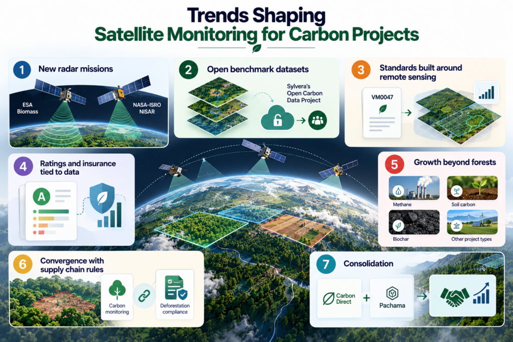
The field moves quickly. These shifts matter most.
- New radar missions: ESA’s Biomass, with its P-band radar, and the NASA and ISRO NISAR mission add fresh ways to see forest structure.
- Open benchmark datasets: Projects such as Sylvera’s Open Carbon Data Project aim to share high-quality forest data with everyone.
- Standards built around remote sensing: Methodologies like VM0047 point toward satellite-based performance benchmarks.
- Ratings and insurance tied to data: Ratings agencies and insurers now lean on geospatial evidence to judge risk.
- Growth beyond forests: Methane, soil carbon, biochar and other project types increasingly use satellite checks.
- Convergence with supply chain rules: Carbon monitoring and deforestation compliance now share the same data and the same providers.
- Consolidation: Deals like Carbon Direct’s acquisition of Pachama show larger players buying monitoring technology.
Expect more partnerships between data providers and ratings agencies. BeZero’s work with Planet and Chloris is a good preview.
Common Mistakes to Avoid
- Treating satellite data as final proof. It is strong evidence, but it needs validation and expert review.
- Ignoring uncertainty. Always ask for error ranges, and plan with them.
- Using only one dataset. Cross-checking sources catches problems early.
- Skipping regional validation. A model that works well in one biome can struggle in another.
- Starting with the wrong boundary. A flawed project map weakens every later step.
- Buying data when you need a rating. Buyers often need independent risk scores, not raw layers.
- Overlooking methodology rules. Check what your standard accepts before you invest.
Conclusion: Choosing Satellite Monitoring for Carbon Projects
Satellite monitoring for carbon projects has become a basic part of how the market earns trust. It lets developers prove their work, helps buyers check their purchases, and gives regulators a shared view.
The ten companies in this guide cover the full picture. Planet offers powerful data. Sylvera and BeZero bring ratings and deep geospatial analysis. Chloris and Space Intelligence focus on biomass and baselines. Pachama, Satelligence and Orbify support buyers and supply chains. Regrow handles farms, and GHGSat tracks methane.
Your best choice depends on your project type, your standard and your budget. Start by defining what you need, ask for validation proof, and test with a pilot.
Satellites do not replace field work or good judgment. But when you combine them with both, you get monitoring that is faster, clearer and far harder to dispute.
Keep exploring Carbon Market Network for more guides on MRV, dMRV and carbon credit quality.
Frequently Asked Questions
What is satellite monitoring for carbon projects?
It is the use of satellite images and sensor data to measure how much carbon a project stores or avoids. Companies combine the data with AI and field measurements to support monitoring, reporting and verification.
How do satellites measure carbon in forests?
Satellites do not count carbon directly. They measure forest height, density and cover using light, radar or lidar. Models calibrated with field data then convert those signals into carbon estimates.
Which companies offer satellite monitoring for carbon projects?
Leading options include Planet Labs, Sylvera, BeZero Carbon, Pachama (part of Carbon Direct), Chloris Geospatial, Space Intelligence, Satelligence, Orbify, Regrow and GHGSat. Each serves a different need.
Can satellites replace field verification?
Not completely. Satellites give frequent, independent coverage, but field plots and airborne surveys remain important for calibration and for checking things satellites cannot see.
How accurate is satellite carbon monitoring?
Accuracy depends on the sensor, the forest type and the validation behind the model. Larger project areas usually show smaller percentage errors. Always ask providers for error ranges in your region.
How often does satellite data update?
It varies. Some imagery refreshes daily, some products update quarterly, and others update annually. Choose the update rate that matches the risks you need to catch.
Does satellite monitoring work for soil carbon?
Yes, but indirectly. Satellites detect practices such as tillage and cover crops. Soil models and samples then estimate the carbon result.
Do carbon registries accept satellite data?
Many methodologies now allow or require remote sensing, and Verra’s VM0047 is one example. Rules differ by standard and methodology, so check yours before you choose a provider.
How much does satellite monitoring for carbon projects cost?
Prices vary widely. Some providers sell data by area, others charge for platform access or full MRV services. Ask for quotes based on your project size and update needs.